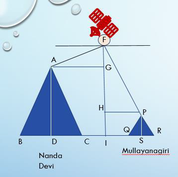
A Satellite flying at height h is watching the top of the two tallest mountains in Uttarakhand and Karnataka ,them being Nanda Devi(height 7,816m) and Mullayanagiri (height 1,930 m). The angles of depression from the satellite , to the top of Nanda Devi and Mullayanagiri are 30° and 60° respectively.
If the distance between the peaks of two mountains is 1937 km , and the satellite is vertically above the midpoint of the distance between the two mountains.